

What we achieve
The project is engaged to promote knowledge exchange across the Mediterranean region for greater success. To facilitates the exchange of knowledge and best practices, the project organizes training sessions and workshops, which build the capacity of local practitioners, decision-makers, and community members to implement and support wetland conservation efforts. This collaborative learning approach ensures that valuable insights and effective strategies are shared and replicated across the region.
5 keys 5 sites

With this project, we hope to advance by:
- Updating and improving knowledge and information on wetland status and their services for climate change adaptation and mitigation;
- Promoting and updating current tools, networks, and collaborations;
- Capitalizing on the knowledge, experiences, and lessons learned;
- Tailoring research work and findings to new and upcoming policies.
- Provide a fresh, approachable communication strategy to spread the word about wetland’s restoration and conservation as a countermeasure to the consequences of climate change.
With 5 pilot sites, we focus on implementing and demonstrating wetland-based solutions to improve carbon sequestration and flood regulation in the the transboundary case of the Struma/Strymon catchment of Bulgaria and Greece, as well as in other seperate wetlands in Oristano-Italy, in Albufera-Spain and in Camargue-France.
By developing and promoting sustainable wetland management practices, the project aims to provide models that can be adopted by local communities and stakeholders and increase their awareness about the importance of wetlands and the benefits of nature-based solutions. Engaging various stakeholders, including local communities, authorities, schools, and institutions, through events, recreational activities, and educational programs helps to establish a deeper connection with wetlands and promotes community involvement in conservation efforts.

5 sites
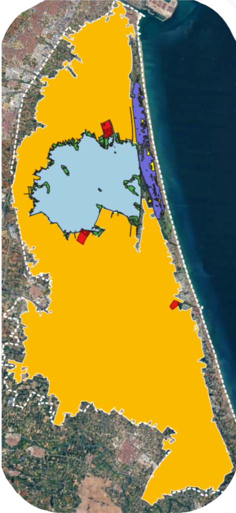
Albufera Natural Park (Spain)
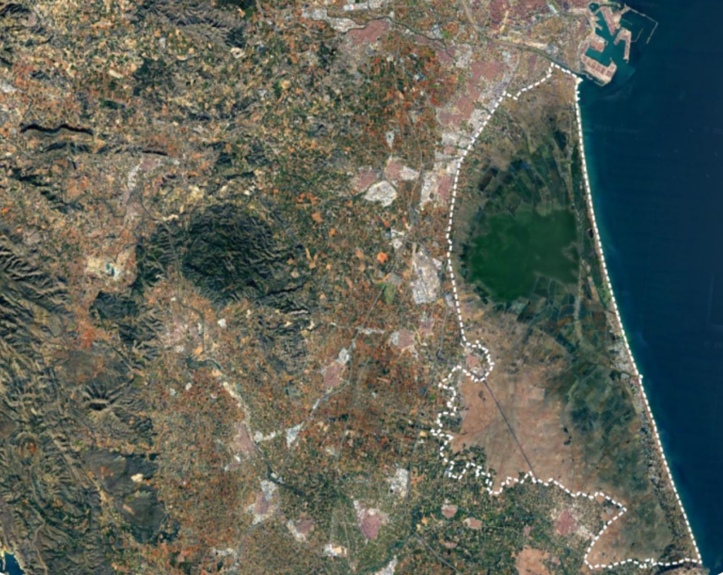
Shallow coastal lagoon (0.5–1 m, ~2,400 ha), now freshwater but eutrophized after decades of nutrient inputs and limited water renewal.
Surrounded by extensive rice fields, forming a strongly managed agro–wetland mosaic where seasonal flooding and drainage shape hydrological connectivity and material exchanges with the lagoon.
The park also includes marshlands and interdune depressions (malladas), which add ecological heterogeneity through distinct hydrological regimes and vegetation types.
Together, these elements create contrasting functional compartments, providing the broader landscape context for the dynamics illustrated in the following panels.
Spatial and temporal dynamics of functional compartments
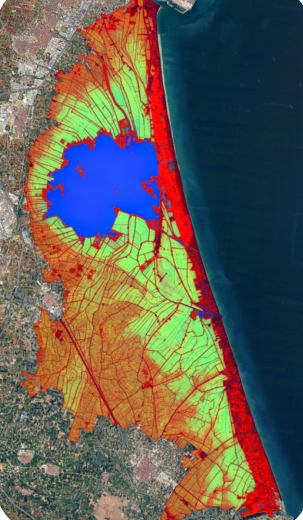
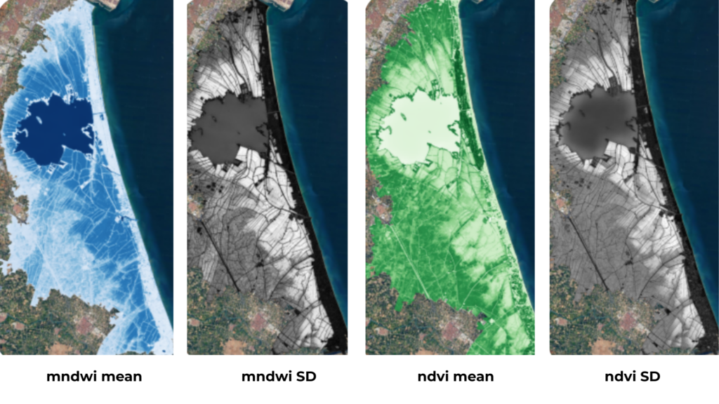
The RGB composite (right) shown in the figure is a synthetic visualisation built by combining multi-year Sentinel-2 metrics (below): Vegetation index NDVI mean (Red), Water index MNDWI Standard Deviation (Green), and water index MNDWI Mean (Blue). This composition merges complementary indicators of vegetation activity and flooding dynamics to highlight functional transitions between distinct landscape compartments.
Permanent water bodies appear in stable blue tones, persistently vegetated areas in red, and zones with fluctuating inundation or mixed cover emerge in intermediate colours. In the Albufera system, this composite reveals a sharp contrast between the consistently water-dominated surface of the main lagoon, with minimal interannual variability, and the surrounding rice fields, with strong seasonal and year-to-year shifts between flooded, exposed, and densely vegetated states. The rice fields closest to the lagoon may appear less green not due to lower crop productivity, but because these depressed areas interact more strongly with the water index: they remain flooded for longer periods, which reduces NDVI expression while amplifying the MNDWI signal. Transitional patterns are especially evident near the land–lagoon interface, where longer flooding periods modulate both soil redox conditions and vegetation turnover, which has implications for the carboon related microbial process. These patterns provide the structural context for understanding carbon-flux behaviour described in the following panel.
Carbon flux patterns and mitigation potential
![]() The lagoon shows clear seasonal shifts. In winter, CO2 and CH4 fluxes remain low, typically below ~20 mg C/m²·h¹. In spring, several stations shift to moderate net CO2 uptake (around –20 to –60 mg C/m²·h¹) and CH4 emissions increase slightly (about 5–10 mg C/m²·h¹). By summer, the lagoon becomes a strong net source, with CO2 commonly rising to 100–200 mg C/m² h¹ and CH4 reaching up to ~20 mg C/m²·h¹. The highest values consistently occur in the northern sector, where emissions peak each season.
The lagoon shows clear seasonal shifts. In winter, CO2 and CH4 fluxes remain low, typically below ~20 mg C/m²·h¹. In spring, several stations shift to moderate net CO2 uptake (around –20 to –60 mg C/m²·h¹) and CH4 emissions increase slightly (about 5–10 mg C/m²·h¹). By summer, the lagoon becomes a strong net source, with CO2 commonly rising to 100–200 mg C/m² h¹ and CH4 reaching up to ~20 mg C/m²·h¹. The highest values consistently occur in the northern sector, where emissions peak each season.
![]() Rice fields exhibit marked seasonality in GHG fluxes, acting as significant sources of CH4 (10–40 mg C/m²·day) during summer flooding due to anoxia, and showing massive CO2 peaks (900–2300 mg C/m²·day) post-harvest driven by aerobic decomposition. Rice management is a key driver: organic fertilization and reclaimed water inputs amplify emissions compared to lagoon-water irrigation. In depressed areas near the lagoon, persistent flooding sustains anaerobic conditions, shifting the balance towards relative higher CH4.
Rice fields exhibit marked seasonality in GHG fluxes, acting as significant sources of CH4 (10–40 mg C/m²·day) during summer flooding due to anoxia, and showing massive CO2 peaks (900–2300 mg C/m²·day) post-harvest driven by aerobic decomposition. Rice management is a key driver: organic fertilization and reclaimed water inputs amplify emissions compared to lagoon-water irrigation. In depressed areas near the lagoon, persistent flooding sustains anaerobic conditions, shifting the balance towards relative higher CH4.
![]() Reed belts dominated by Phragmites show strong photosynthetic CO2 uptake under light conditions (typically –100 to –300 mg C/m²·h), while dark incubations indicate moderate respiration (usually < 50 mg C/m² ·h). CH4 emissions remain low to moderate for most of the year (1–5 mg C/m²·h), rising slightly (>10) in persistently flooded patches with thicker organic deposits. These helophytes stands act overall as seasonal CO2 sinks, with CH4 production controlled by flooding and sediment anoxia.
Reed belts dominated by Phragmites show strong photosynthetic CO2 uptake under light conditions (typically –100 to –300 mg C/m²·h), while dark incubations indicate moderate respiration (usually < 50 mg C/m² ·h). CH4 emissions remain low to moderate for most of the year (1–5 mg C/m²·h), rising slightly (>10) in persistently flooded patches with thicker organic deposits. These helophytes stands act overall as seasonal CO2 sinks, with CH4 production controlled by flooding and sediment anoxia.
![]() The Wetlands (Malladas) from dune slack system display strong summer CO2 emissions, typically 800–2,000 mg C/m²·d, driven by rapid aerobic decomposition in warm, well-drained sandy soils. Spring and fall-winter fluxes remain much lower (<300 mg C/ m²·d). CH4 emissions are generally modest but can reach 40–70 mg C m²·d under shallow summer flooding. Even so, reeds belt around the basins provides substantial seasonal CO2 uptake, and its annual biomass production offsets these metabolic losses, yielding some years an overall net sink of roughly –10 to –15 Tn CO2-eq/ha· yr.
The Wetlands (Malladas) from dune slack system display strong summer CO2 emissions, typically 800–2,000 mg C/m²·d, driven by rapid aerobic decomposition in warm, well-drained sandy soils. Spring and fall-winter fluxes remain much lower (<300 mg C/ m²·d). CH4 emissions are generally modest but can reach 40–70 mg C m²·d under shallow summer flooding. Even so, reeds belt around the basins provides substantial seasonal CO2 uptake, and its annual biomass production offsets these metabolic losses, yielding some years an overall net sink of roughly –10 to –15 Tn CO2-eq/ha· yr.
![]() The Artificial wetlands (Tancats) receiving drainage from the rice fields, show carbon flux patterns similar to those reported for comparable treatment systems in the region, with inlet zones reaching CO2 values of a few tens up to around two hundred mg C/m²·h and CH4 occasionally in the tens of mg C m²·h under organic-rich, reduced conditions. Along the flow path, both gases decline as particulate matter is retained and redox conditions improve. Beyond nutrient removal, the dense emergent vegetation also provides substantial seasonal CO2 uptake, acting as an additional carbon sink besides reducing nutrient load entering the lagoon.
The Artificial wetlands (Tancats) receiving drainage from the rice fields, show carbon flux patterns similar to those reported for comparable treatment systems in the region, with inlet zones reaching CO2 values of a few tens up to around two hundred mg C/m²·h and CH4 occasionally in the tens of mg C m²·h under organic-rich, reduced conditions. Along the flow path, both gases decline as particulate matter is retained and redox conditions improve. Beyond nutrient removal, the dense emergent vegetation also provides substantial seasonal CO2 uptake, acting as an additional carbon sink besides reducing nutrient load entering the lagoon.
![]() The pine forest of the Devesa, established on the coastal dune ridge, represents a large above- and below-ground C reservoir. However, this C pool is highly vulnerable to fire, and the risk of large emissions is exacerbated by prolonged drought, hotter summers, and increasing fuel dryness. Although many ignitions are human-related, climate-driven aridification amplifies fire incidence and severity.
The pine forest of the Devesa, established on the coastal dune ridge, represents a large above- and below-ground C reservoir. However, this C pool is highly vulnerable to fire, and the risk of large emissions is exacerbated by prolonged drought, hotter summers, and increasing fuel dryness. Although many ignitions are human-related, climate-driven aridification amplifies fire incidence and severity.
Lake Kerkini (Greece)
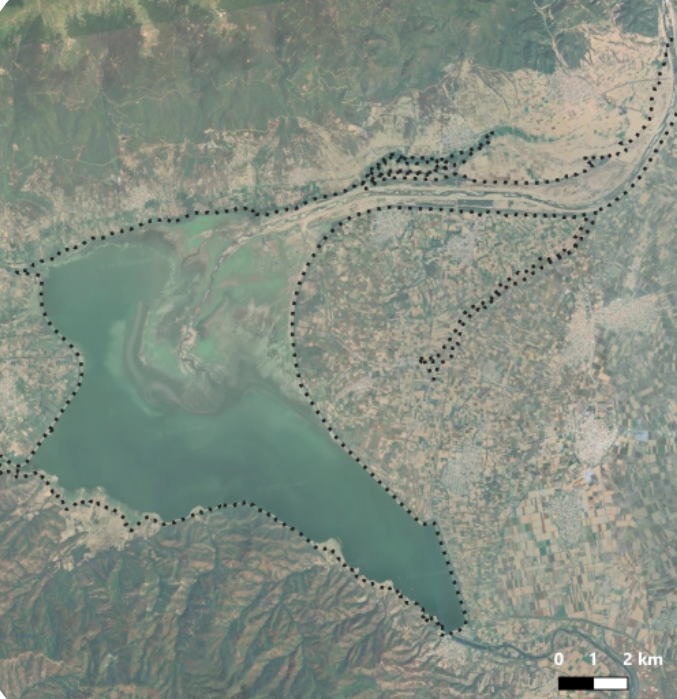
Kerkini is an artificial inland freshwater lake of around 11 ha, created in 1932 over a former swamp in northern Greece (Central Macedonia, Serres). It is a Ramsar Site and Natura 2000 Special Protection Area, with priority alluvial-forest habitats in its delta. The lake lies on an alluvial plain between the Kerkini and Mavrovouni mountains, bordered by agricultural land and forested slopes. The climate is transitional between Mediterranean and Mid-European, with ~445 mm of annual rainfall, from a dry minimum in September to a wet peak in November. Lake is fed by the Strymon River, whose average discharge of roughly 65–83 m³/s can drop to almost zero in summer due to upstream retention. These inflows drive the lake’s pronounced annual water-level fluctuations, which exceed 5 m, reaching their minimum between September and February and rising to a maximum in May–June. The sustained delivery of sediments has formed a large internal delta, historically receiving up to ~10 × 10⁶ m³/yr of material, but has posteriorly decreased to lower deposition rates.
This river-influenced sector contains a mosaic of habitats, including riparian Salix stands, remnants of alluvial forest, and extensive floating vegetation (Nymphaea alba, Nymphoides peltata), with formerly widespread reedbeds now reduced. Despite these shifts, it remains an important breeding and feeding area for fish, amphibians, reptiles and birds, shaped by the Strymon’s strong seasonal fluctuations.
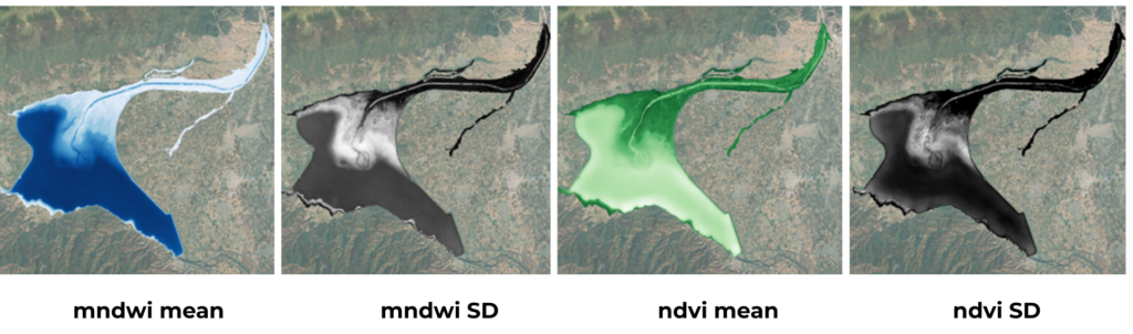
Spatial and temporal dynamics of functional compartments
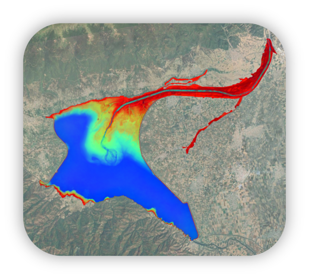
The RGB composite (left) shown in the figure is a synthetic visualisation built by combining multi-year Sentinel-2 metrics (below): Vegetation index NDVI mean (Red), Water index MNDWI Standard Deviation (Green), and water index MNDWI mean (Blue). This composition merges complementary indicators of vegetation activity and flooding dynamics to highlight functional transitions between distinct landscape compartments.
The multi-year RGB composite captures the strong seasonal water-level amplitude of Lake Kerkini, with extensive annual drawdown and refilling shaping the spatial arrangement of vegetation and open-water areas. High MNDWI water index variability highlights zones subjected to recurrent exposure–inundation cycles, while the deep-water parts show a more stable flooding. The vegetation NDVI index patterns reveal productive belts of emergent, submerged, and floating vegetation that shift position as water levels fluctuate, producing marked transitions between macrophyte-dominated margins and open-water sectors. The retreat and advance of shoreline vegetation, together with patches where floating plants replace former reedbeds, point to ongoing adjustments in plant functional composition driven by hydrological oscillations. These combined spectral indicators underscore a system where annual water-level dynamics is controlling habitat distribution, vegetation structure, and the hydrological linkages between shallow vegetated margins and the deeper open-water zone. This creates a environmental context that may shape the direction and magnitude of GHG exchange.
Carbon flux patterns and mitigation potential
Kerkini has already advanced toward a process-based assessment, combining in-situ CO2 flux measurements with functional interpretations derived from hydrology, flooding dynamics, and vegetation patterns. Completing a full process-level evaluation will, however, require additional field campaigns to improve temporal coverage, incorporate direct measurements of plant structure and biomass, and include methane fluxes.
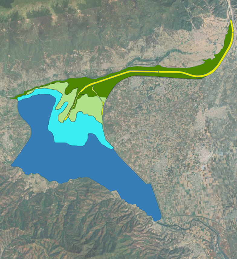
![]() Sampling points within the deepest, permanently inundated areas, act as the strongest CO2 sinks, showing uptake around –50 mg CO2/m²·h, a pattern favoured by stable water column that buffer sediment–atmosphere GHG transfer, but also suggests occurrence of a sustained photosynthetic demand, which must be confirmed in following sampling campaigns.
Sampling points within the deepest, permanently inundated areas, act as the strongest CO2 sinks, showing uptake around –50 mg CO2/m²·h, a pattern favoured by stable water column that buffer sediment–atmosphere GHG transfer, but also suggests occurrence of a sustained photosynthetic demand, which must be confirmed in following sampling campaigns.
![]() Shallow areas, but consistently flooded, also act as net CO2 sinks, though of lower magnitude (≈ –20 mg CO2/m² h), reflecting moderated respiration and partial biological uptake in macrophyte-rich margins.
Shallow areas, but consistently flooded, also act as net CO2 sinks, though of lower magnitude (≈ –20 mg CO2/m² h), reflecting moderated respiration and partial biological uptake in macrophyte-rich margins.
![]() The intermittently flooded area shows in contrast higher emissions, typically around 150 mg CO2 m²·h, a pattern enhanced by alternating exposure–inundation cycles and by the human-impacted depositional zone formed by Strymon River inputs, where sediment delivery likely promotes microbial oxidation activity and metabolic turnover.
The intermittently flooded area shows in contrast higher emissions, typically around 150 mg CO2 m²·h, a pattern enhanced by alternating exposure–inundation cycles and by the human-impacted depositional zone formed by Strymon River inputs, where sediment delivery likely promotes microbial oxidation activity and metabolic turnover.
![]() The soils from the dry outer area form the most emissive compartment, with fluxes approaching 300 mg CO2/m²·h, driven by exposed sediments and the resulting enhanced aeration. However, the presence of vegetation in this zone will need to be considered in upcoming campaigns, through flux measurements on the more dynamic plant components and by assessing carbon stocks in the more stable, woody vegetation.
The soils from the dry outer area form the most emissive compartment, with fluxes approaching 300 mg CO2/m²·h, driven by exposed sediments and the resulting enhanced aeration. However, the presence of vegetation in this zone will need to be considered in upcoming campaigns, through flux measurements on the more dynamic plant components and by assessing carbon stocks in the more stable, woody vegetation.
![]() Strymon River has to be considered as a distinct functional zone, experiencing frequent hydrological fluctuations, high turbidity, and rapid turnover. These conditions can stimulate CO₂ emissions, and in any case strongly regulate its seasonal dynamics.
Strymon River has to be considered as a distinct functional zone, experiencing frequent hydrological fluctuations, high turbidity, and rapid turnover. These conditions can stimulate CO₂ emissions, and in any case strongly regulate its seasonal dynamics.
Marceddì-San Giovanni lagoon system (Italy)
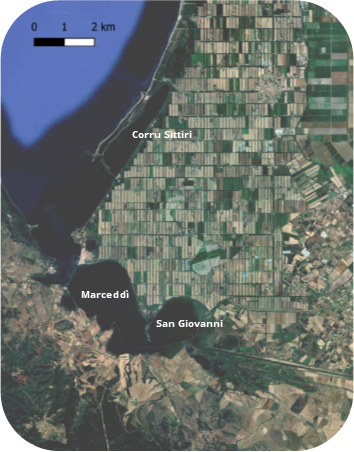
The Marceddì–San Giovanni lagoon complex, on the southern coast of the Gulf of Oristano (Sardinia), forms an interconnected system of shallow coastal wetlands where marine influences, river inputs, and pressures from agriculture and traditional fisheries converge.
Marceddì Lagoon is a shallow polihaline basin directly influenced by seawater through the fishpond bridge, characterised by stable salinity, sandy–silty sediments with low organic-matter content, and relatively persistent open-water conditions shaped by controlled marine exchange and long-standing fishing activity.
San Giovanni Pond is a more enclosed mesohaline basin fed by the Mogoro, Mannu and Sitzerri rivers. It holds organic-rich sediments and extensive emergent vegetation, with a hydrology shaped by strong seasonal inflows and agricultural drainage.
Corru S’Ittiri Lagoon, located to the north, is a shallow eurihaline basin exposed to variable marine intrusions. It contains intermediate organic-matter levels, with halophytic marshes and intermittently flooded flats, and shows notable fluctuations in salinity and water extent.
Spatio-temporal dynamics of functional compartments
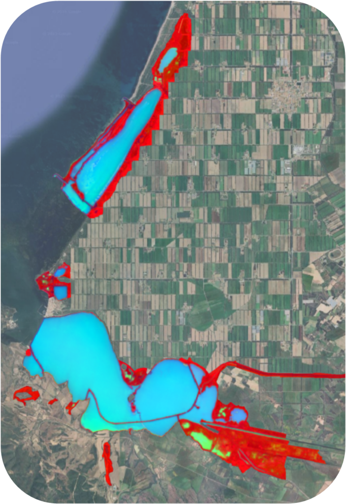
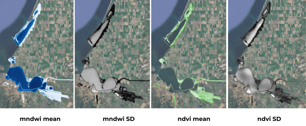
The RGB composite (right) shown in the figure is a synthetic visualisation built by combining multi-year Sentinel-2 metrics (below): Vegetation index NDVI mean (Red), Water index MNDWI Standard Deviation (Green), and water index MNDWI mean (Blue). This composition merges complementary indicators of vegetation activity and flooding dynamics to highlight functional transitions between distinct landscape compartments.
Remote-sensing indicators reveal a clear spatial structure across the lagoon system. The MNDWI mean outlines the main open-water bodies, while the water-variability layer highlights pronounced fluctuations along the shallow southern fringe of Marceddì, where a broad low-depth platform responds strongly to small water-level changes. San Giovanni shows more moderate seasonal dynamics, and Corru S’Ittiri remains comparatively stable.
The NDVI pattern is heterogeneous across all three basins, reflecting the mosaic of vegetated margins typical of Mediterranean coastal wetlands. Zones of higher productivity coincide with the freshwater-influenced reedbeds of San Giovanni, while halophytic communities characteristic of the northern sector appear as more spatially fragmented patches. Around Marceddì, vegetation tends to form narrower coastal fringes shaped by its polihaline regime. These spatial signals, together with ecological knowledge of the site’s vegetation types, help to delineate the main functional strata that underpin hydrological behaviour and carbon-uptake potential across the system.
C-flux patterns and mitigation potential
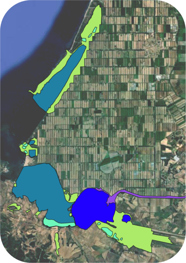
![]() First GHG rates measures conducted in San Giovanni show modest CO2 uptake in the water column, with values ranging from –3 to –7 mg C/m² h¹, and CH4 emissions generally low (~0.5 mg C/m2·h), being higher in sectors more closer to the freshwater inputs from the river.
First GHG rates measures conducted in San Giovanni show modest CO2 uptake in the water column, with values ranging from –3 to –7 mg C/m² h¹, and CH4 emissions generally low (~0.5 mg C/m2·h), being higher in sectors more closer to the freshwater inputs from the river.
![]()
Saline open waters in Marceddì also exhibit CO2 assimilation rates close to –6 mg C/m² h, combined with CH4 emissions of around 1 mg C m² h.
![]() No direct measurements have yet been taken in the seasonally flooded areas, but studies in similar Mediterranean wetland margins show that shallow, intermittently inundated soils can shift rapidly between CO2 uptake when briefly vegetated and CO2 or CH4 release during waterlogging, driven by alternating oxic–anoxic conditions.
No direct measurements have yet been taken in the seasonally flooded areas, but studies in similar Mediterranean wetland margins show that shallow, intermittently inundated soils can shift rapidly between CO2 uptake when briefly vegetated and CO2 or CH4 release during waterlogging, driven by alternating oxic–anoxic conditions.
![]() In vegetated areas, combining satellite-derived indices with ground observations helps distinguish dense, stable communities, which maintain steadier below-ground carbon stocks, from more seasonally dynamic zones . For halophytic vegetation, early measurements indicate notable CO2 uptake, with rates of about –46 mg C/m² h¹ during the growing season.
In vegetated areas, combining satellite-derived indices with ground observations helps distinguish dense, stable communities, which maintain steadier below-ground carbon stocks, from more seasonally dynamic zones . For halophytic vegetation, early measurements indicate notable CO2 uptake, with rates of about –46 mg C/m² h¹ during the growing season.
![]()
Mediterranean temporary streams often show CO2 outgassing during low-flow phases and after the first rains, so, although not yet measured here, a similar pattern may be expected.
Content of the Struma site will be soon shared.
Content of the Camargue site will be soon shared.