

Wetland4Change explores how wetlands can contribute to climate adaptation and mitigation through two key ecosystem services: carbon sequestration (WP1) and flood regulation (WP2). While these functions are often studied separately, in reality they are deeply interconnected and strongly influenced by hydrological processes occurring across entire river basins.
The Bulgarian pilot site offers a particularly valuable perspective on this relationship. Located within the Struma catchment, one of the largest river systems in Bulgaria, the area includes a diverse network of wetlands shaped by river dynamics, seasonal flooding, sediment transport and upstream land-use pressures. Rather than focusing on a single wetland, the pilot investigates how a mosaic of nearly 200 wetlands collectively contributes to flood mitigation, carbon storage and climate resilience at landscape scale.
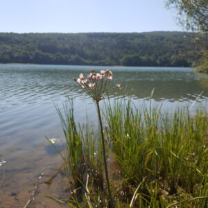
Struma wetlands climate adaptation – Dam Izvor Bulgaria – Wetland4Change
To better understand these dynamics, we spoke with Stanimira Ivanova and Petar Petrov, from the University of Forestry Sofia, representatives of the Bulgarian pilot site and lead partner of the Wetland4Change project. Beyond coordinating the project at transnational level, their team is directly involved in the management and assessment of the Struma catchment wetlands, providing a unique perspective that combines scientific research, practical management and policy implementation.
In this interview, they explain why river connectivity, hydrological variability and catchment-scale governance are essential for understanding both flood regulation and carbon dynamics, and how nature-based solutions can strengthen the resilience of wetlands and communities facing increasing climate pressures.
In river-influenced systems like Struma, how does hydrological variability shape the role of wetlands in both flood regulation and carbon dynamics?
In a river-influenced system like the Struma, hydrological variability is probably the main driver of wetland functioning. The same wetland can behave differently depending on whether the system is in a high-flow, low-flow, or post-flood phase. During high river discharge, wetlands and floodplain areas can temporarily store water, slow down flow velocity and reduce flood peaks. During drier periods, however, their role shifts towards maintaining soil moisture, supporting vegetation, and sustaining carbon accumulation.
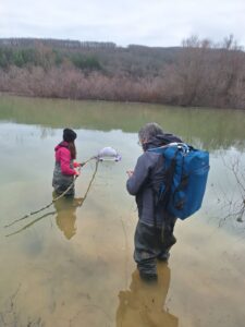
Carbon Fluxes analysis at the Struma Catchment – Bulgaria | Wetland4Change
For carbon dynamics, this variability is equally important. Permanently or frequently inundated areas tend to slow down organic matter decomposition and support carbon storage in sediments and vegetation. At the same time, prolonged anoxic conditions may increase methane emissions. Seasonally fluctuating areas can accumulate carbon during wet phases, but drying periods may enhance aerobic decomposition and CO₂ release. This is why in Wetland4Change we do not look at wetlands only as static land-cover units, but through their hydroperiod, vegetation, soil and connectivity characteristics.
Petar Petrov University of Forestry Sogia (Bulgaria) – Wetland4Change
Compared to more stable systems, how does the influence of river discharge and sediment transport affect wetland functioning?
Compared to more stable wetlands, river-driven systems are much more dynamic and externally controlled. River discharge determines how often wetlands are connected, flooded or isolated, while sediment transport shapes their morphology, nutrient status and long-term capacity to store organic matter.
Sediment input can be beneficial because it supports soil formation, nutrient renewal and carbon burial. But it can also become a pressure when sediment loads are excessive, contaminated or linked to upstream erosion and land-use change. In the Struma catchment, this means that wetland functioning cannot be understood only at site level. The wetland reflects what happens upstream – rainfall, land use, erosion, river regulation and water abstraction.

Stanimiraa Ivanova – University of Forestry – Sofia Bulgaria
What are the main challenges in assessing flood regulation capacity in a system that is strongly influenced by upstream conditions?
The main challenge is that the flood regulation capacity of a wetland is not determined only by the wetland itself. It depends on the entire upstream catchment: precipitation patterns, slope, soil permeability, vegetation cover, land use, river network, reservoirs, drainage and existing floodplain connectivity.
In Wetland4Change, this is addressed through a catchment-scale methodology using hydrological modelling, especially the SCS Curve Number approach, and by combining indicators such as runoff generation potential, flood-prone areas, risk mitigation capacity and wetland water regulation capacity. This helps us avoid a simplistic answer such as “this wetland regulates floods” and instead ask: under which conditions, at which location, and for whom does it provide the service?
How important is it to consider the entire catchment when working on wetlands like Struma?
It is essential. For Struma, the catchment is not just background context, it is part of the wetland system. Flood peaks, sediment loads, nutrient inputs and hydrological connectivity are all generated or modified at catchment scale.
This is also why the Bulgarian pilot is particularly valuable for Wetland4Change. The project assesses 197 small and medium wetlands in the Struma catchment, with more detailed attention to sites such as Chokliovo Marsh and Yazovir Izvor. This allows us to understand not only individual wetlands, but also their cumulative role in climate adaptation, flood regulation and carbon storage at landscape level.
medsea-foundation-1-300x139.jpg)
Are you already observing differences between more permanently inundated areas and those exposed to seasonal fluctuations?
Yes, and this is one of the most important observations. Permanently inundated areas generally have higher potential for water storage and sediment carbon accumulation, especially where vegetation and low oxygen conditions slow decomposition. However, they may also create conditions for methane production.
Seasonally fluctuating areas are more variable. They can support high productivity during wet periods, but when they dry out, oxygen enters the soil and decomposition accelerates. In Struma, the project results distinguish between permanent wetland types, such as reservoirs, permanent freshwater marshes and peatlands and seasonal systems, such as seasonal freshwater marshes. Their carbon storage potential and emission risks are different, so they require different management priorities.
How does sediment input influence carbon processes and ecosystem functioning in these environments?
Sediment input is a double-edged process. On one hand, sediment deposition can support carbon burial, especially where organic matter is trapped and protected under saturated conditions. This is particularly relevant for reservoirs, ponds and marshes, where reduced flow energy allows material to settle.
On the other hand, sediment input can also carry nutrients and organic loads from upstream areas. If this leads to eutrophication or oxygen depletion, the system may shift from being a carbon sink towards becoming a greenhouse gas source, especially through methane emissions. So the question is not only how much sediment enters the wetland, but what kind of sediment, from where, and under what hydrological conditions.
In systems with strong external pressures, what are the limits of local wetland management?
Local management is necessary, but not sufficient. At site level, we can improve vegetation structure, avoid drainage, restore small retention areas, maintain water levels and reduce direct disturbance. But if upstream pressures continue (erosion, nutrient pollution, altered discharge, channelization or water abstraction), the local wetland will remain vulnerable.
This is why Wetland4Change places strong emphasis on governance and transferability. Wetlands-based solutions work best when they are embedded in river basin planning, agricultural policy, climate adaptation plans and local spatial planning. Otherwise, we risk improving a wetland locally while the drivers of degradation remain unchanged upstream.
Stanimiraa Ivanova – University of Forestry – Sofia Bulgaria
Concerning the Flood regulation: In a river-driven system, what role do wetlands play in buffering peak flows?
Wetlands buffer peak flows by giving water space. They store part of the flood volume, slow down flow velocity through vegetation and surface roughness, and delay the downstream movement of the flood wave. This does not mean that wetlands can stop extreme floods, but they can reduce the speed, intensity and destructive power of floodwaters.
In the Struma results, the flood regulation supply map shows that the service is not uniform across the basin. Higher supply is associated with areas where land cover, infiltration potential, vegetation and wetland/water regulation capacity combine positively.
How does connectivity between river channels and adjacent wetlands influence flood mitigation capacity?
Connectivity is fundamental. A wetland can regulate floods only if water can reach it at the right moment and leave it gradually afterwards. Connected floodplain wetlands act as natural retention and dissipation zones. They receive excess water during high flows and release it more slowly, reducing pressure downstream.
If wetlands are disconnected from the river by embankments, drainage, infrastructure or channel incision, their flood mitigation role is strongly reduced. They may still have biodiversity or carbon value, but their ability to buffer flood peaks becomes limited.
What are the risks when this connectivity is altered or reduced?
When connectivity is reduced, floodwater remains confined to the river channel, which increases flow velocity and downstream flood risk. At the same time, the wetland may dry out, lose vegetation structure, lose sediment input and gradually lose its carbon storage function.
So the risk is double: reduced flood protection and degraded ecosystem functioning. In the long term, disconnection can turn a multifunctional wetland into an isolated habitat with lower resilience and lower capacity to support climate adaptation.
What types of interventions could realistically improve both flood regulation and ecosystem resilience in a system like Struma?
The most realistic interventions for Struma wetlands climate adaptation are those that work with the river, not against it. For Struma, I would prioritise:
– restoring or maintaining lateral connectivity between river channels and floodplain wetlands;
– protecting existing marshes, ponds and peatland areas from drainage or conversion;
– improving riparian vegetation and natural buffer strips;
– reducing upstream erosion and nutrient inputs;
– restoring small retention areas and degraded wetland patches;
– integrating wetlands into municipal and river basin flood-risk planning.
These measures are realistic because they do not require one single large intervention. They can be implemented gradually, but together they increase retention, slow runoff, improve habitat quality and protect carbon stocks.
Where do you see the greatest opportunity for nature-based solutions in this context?
The greatest opportunity is in using wetlands as part of a catchment-scale climate adaptation strategy.
In Struma, wetlands are not only isolated conservation sites; they are part of a larger natural infrastructure that can reduce runoff, store water, retain sediments, support biodiversity and contribute to carbon regulation.
The Wetland4Change results are important because they make these benefits visible and spatially explicit. The supply and demand maps show where the ecosystem has higher regulation capacity and where human assets and population are more exposed.
This helps decision-makers move from a general statement “wetlands are useful” to concrete prioritisation: where to protect, where to restore, and where nature-based solutions can bring the highest adaptation benefit.
